Get a Look at This: Texas Water (Drought) Maps
Having taken several months off from the intense war on water waste, I lost track of what the Texas State Government has done to improve the quantity and quality of information related to the Texas drought.
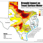
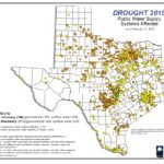
What I found is the Texas Commission for Environmental Quality site that has a water “gateway” page loaded with links to information and MAPS related to Texas water supplies, usage and conditions. The quantity of information looks bottomless. After looking at the maps, I couldn’t think of a better way today to show and tell you in a concise way- exactly what is happening at the start of 2015.
CLICK ON THE MAP TO GET LARGEST VIEW!
CLICK ON THIS MAP TO ENLARGE IT!


You must be logged in to post a comment.